The Mobile Digital Communicator (MDC) has been designed to provide Automated Vehicle Location (AVL) capability. This is accomplished via an interface with Global Positioning Satellite (GPS) receivers that adhere to the NMEA (National Marine Electronics Association) 0183 standards. Having a GPS receiver connected to your MDC workstations in the field allows for the automatic transmission of real time latitude and longitude coordinates back to CAD / Dispatch so that dispatchers as well as other MDC users can view field units spatially via the MDC or CAD map display. This allows you to know where all units are at all times and provides an invaluable tool to aid in overall officer safety in the field.
* The NMEA 0183 standard defines the electrical signaling requirements, data transmission protocol and time, and specific sentence formats for a 4800-baud serial data bus. NMEA 0183 compliant GPS devices provide excellent results for a typical MDC application and are widely available from many commercial retailers and on-line suppliers (many on E-bay) and are relatively inexpensive with good quality units being available for under $100.00 The placement of the GPS receiver on your vehicle is critical. For best results the GPS Receiver should be either mounted in an unobstructed location such as outside the vehicle on the roof or trunk lid of the vehicle avoiding any lights or other equipment that may be mounted there. If it is necessary to mount the receiver inside the vehicle, the receiver should be placed at the base of either the front or read window where the signal can be received thru the vehicle glass.
The
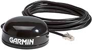
Garmin GPS receiver pictured above is for illustration purposes only.
Garmin is one of many manufacturers that produce and provide NMEA
0183 compatible GPS receivers. Some manufacturers, like Garmin,
also provide receivers that only output a proprietary data format. Crimestar
recommends that you avoid such devices. If you already have a GPS
device that does not provide NMEA 0183 output, there are converter programs
such as "GPSGate"that will convert the output of different devices
to NMEA 0183.
The
Crimestar MDC workstation can be used to visually show field event and
unit data in a spatial map format. In order to do this, each MDC
workstation must able to notify the MDC controller of its respective latitude
and longitude coordinate location on an ongoing basis. To facilitate
this process the MDC workstation software has been designed to interface
with National Marine Electronics Association (NMEA 0183) compliant Global
Positioning Satellite (GPS) receivers. Once interfaced to a GPS device
the MDC workstation sends GPS latitude and longitude coordinate data with
each respective transmission, and/or upon regular time intervals and/or
upon traveling or changing coordinates within a predefined tolerance (movement).
The serial port used by the MDC workstation to receive the GPS data,
the time intervals and the movement parameters are controlled by the following
Crimestar INI settings:
GPS_PORT=
GPS_DISTANCE=
GPS_TIME=
The above settings apply
only to the MDC Workstation. They are meaningless on the MDC Controller.
See MDC INI File Settings
for information on configuration settings.
The MDC is designed to
receive NMEA 0183 compliant input via a standard RS-232 serial com port
at 4800 Baud, No Parity, 8 data bits and 1 stop bit (4800,N,8,1). Some
GPS devices connect to the computer via USB and create a virtual com port
on your computer rather than connecting to a physical com port. These
devices will also work, providing you have the device drivers to create
the virtual com port and know which com port the device is assigned to.
The Crimestar MDC software will not communicate directly via the
Universal Serial Bus Controller.
Once the appropriate comport has been identified, set the GPS_PORT entry
of the Crimestar INI file to that respective value and start or restart
the MDC software to connect. (Note: a serial com port can only be opened
by one program at a time, so if any other program is accessing that com
port you must quit the other program before the MDC software will be able
to open that port and read the GPS data) Once connected, the MDC
workstation specifically watches for the input of an “RMC” data message.
Make sure that the GPS device you use is configured to send RMC data strings.
The following is an example of that specific input string:
RMC - Recommended minimum specific GPS/Transit data
RMC,225446,A,4916.45,N,12311.12,W,000.5,054.7,191194,020.3,E*68
225446 Time of fix 22:54:46 UTC
A Navigation
receiver warning A = OK, V = warning
4916.45,N Latitude 49 deg. 16.45 min North
12311.12,W Longitude 123 deg. 11.12 min West
000.5 Speed over ground, Knots
054.7 Course Made Good, True
191194 Date of fix 19 November 1994
020.3,E Magnetic variation 20.3 deg East
*68 mandatory checksum
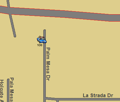
Once the MDC workstation begins receiving valid RMC data input from the GPS device the GPS indicator (G) in the upper right corner of the MDC Workstation will switch from red to green. This indicates that the MDC software is communicating with the GPS device and that a latitude and longitude coordinate fix has been established by the GPS receiver and that the navigation receiver warning indicator provided as part of the RMC data string is OK (”A”) . If the MDC workstation stops receiving RMC data from the GPS receiver for a period of more than 60 seconds or if the GPS receiver sends an RMC record with a navigation receiver warning indicator of warning (“V”) the MDC workstation GPS indicator (G) will revert back to red. A Yellow means that the MDC software is receiving a signal from the GPS device,however the Navigation Receiver Warning indicator is a "V" and the GPS does not have a fix on it's location.
(G) = No RMC signal being received from GPS hardware.
(G) = RMC Signal Received but Navigation Coordinates cannot be confirmed by the hardware.
(G) = RMC Signal Received and Navigation Coordinates Confirmed.
You can view the actual RMC data record being received by the MDC workstation software from the GPS receiver via the MDC Radio Statistics Display diagnostic window which can be activated from the View Menu. Once the Message Statistics Display window is active, the GPS NMEA DATA RECEIVED field will automatically update on the form in real time showing the most recent coordinate fix received from the GPS device.
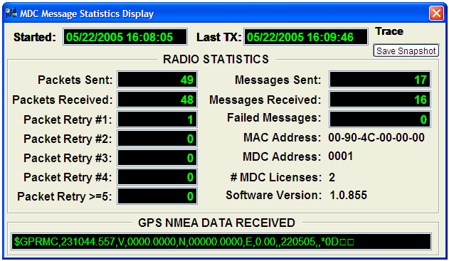
For best system performance during normal MDC operation this special Message Statistics Display window should remain closed.
The
MDC Controller can be configured to log the unit GPS coordinate information
at regular time intervals creating snap-shots of field unit location data.
This is accomplished by setting the LOG_LAT_LNG_FREQUENCY= configuration
parameter of the Crimestar INI file to a value greater than zero where
the value represents, in minutes, the frequency of the unit GPS logging.
Turning
GPS logging on will create a text file named “MDCLLLOG.TXT” in the program
directory/folder which will contain one record for each GPS enabled unit
at each snapshot time interval. This text file is a variable length
delimited file using the vertical bar “|” as the delimiter character.
The file contains the Date-Time, MDC ID, Unit ID, Latitude, Longitude,
Speed, Compass Heading and Unit Status. The file format looks similar
to the following example:
10/17/2006 15:18:06|145|006|37237200|-121761000|19|273|AV
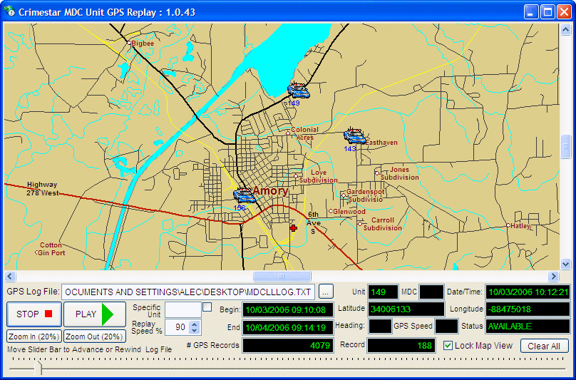
Once
a GPS log file has been created it can be later replayed using the “gpsreplay.exe”
application which is also distributed during an MDC software installation.
The GPS Replay application reads an MDCLLLOG file and replays the
movement of each respective GPS enabled unit over a given period of time.
* A STRONG WORD OF CAUTION: GPS enabling field units is one of the most important things you can do to aid in the safety of your officers. It can assist others in locating a unit in order to render aid or assistance in an emergency. While Crimestar MDC provides the ability to replay or retrace historical unit movement and activity, use of such information for administrative disciplinary actions is discouraged. If/when field officers view the MDC’s GPS as a “big brother” device that will be used against them, they may choose to intentionally unplug, break or disable the GPS device in order to avoid being tracked. If and when this happens, the more important officer safety aspect of GPS tracking is compromised!