
The CAD Map status monitor displays all unit and event activity in a graphical
map format. Event data is mapped based on either latitude and longitude
coordinates supplied as a result of a geo-file verification or manually
geo-coding the event on-the-fly, by dispatcher referencing the proper location
for the event on the CAD Map using the computer mouse. Units are mapped
based on latitude and longitude coordinates received from
GPS equipped field units running Crimestar's Mobile
Digital Communicator software (licensed separately from CAD). The CAD
Map status monitor is always run as a desktop form and generally requires the
use of a multiple monitor or dual monitor computer workstation. Similar to the Unit Status
and Event Status monitors, the Map status monitor can be resized as desired
and can be used interactively via drag & drop operations to update units or
events accordingly.
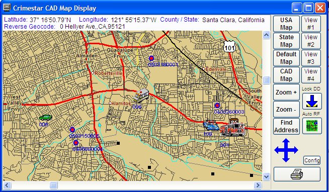
The CAD Map status monitor provides 4 default views (USA, State, user defined
Default and the Dynamically Calculated, based on event and unit locations "CAD
Map") and 4 run-time changeable static views. In addition to these
pre-defined and dynamic views the map display can be panned and zoomed as
desired. This allows the operator to quickly navigate the map display to
the area or view desired.
![]()
Copyright © 1999-2021 Crimestar USA, LLC - All Rights Reserved